

A 300-year-old map of the transfer of landownership went online today. The Down Survey of Ireland, which has been uploaded by the history department in Trinity College, was of the forced Cromwellian plantation between 1656 and 1658.
The project to bring the map online was led by professor of modern history at Trinity College Dr Micheál Ó’Siochrú, along with a team of historians who traced over 2,000 copies of the original survey maps from libraries and archives.
Mr Ó’Siochrú said the map’s website is an extraordinary and unique resource of early modern Irish history, which will completely change our understanding of 17th century Ireland.
“Preliminary research based on on-going work suggests that our understanding of the scale and timing of the massive transfer of land from Catholic to Protestant landholders will need to be reassessed,” he said.
“The bringing together of this highly detailed map collection and related contemporaneous material with the aid of GIS technology allows us to reconstruct this period of Irish history. It will be of great interest to historians, genealogists, sociologists, engineers and anyone with an interest in Ireland, its past and its people.”
The website is downsurvey.tcd.ie , will allow users to explore 17th century Ireland in detail through use of GIS technology. Site visitors will also be able to search a database of 10,000 landowners. It is definitely recommended.
Cromwell, Oliver: To Hell or to Connaught
Oliver Cromwell spent nine months in Ireland subduing by force most of the resistance to English rule. However, the job would not be complete to Cromwell’s satisfaction until Ireland was secure for all time as part of the Commonwealth of England , Scotland and Ireland . To finish his work, Cromwell returned to England to start the legislative suppression of Ireland while his son Henry Cromwell completed the military campaign. Cromwell and the Parliament passed the Act of Settlement of Ireland in 1653 whose goal was the massive transfer of land from Irish hands to English hands. The map in this article shows the plantation plan for Ireland , including pushing “the habitation of the Irish nation” to Connaught and Clare, giving the still resisting Irish the choice to go “To Hell or to Connaught .” To complete his work in Ireland , Cromwell had several pressure groups to satisfy. One powerful group was the Adventurers who had bought acreage in Ireland on speculation in the early 1640s. Their investment was authorized by an act which declared forfeit 2,000,000 acres of Irish land as punishment for the rising of 1642. These Adventurers, called so because theirs was a risky investment in an adventure which was highly unpredictable, were able to buy up Irish land cheaply, for example £300 for 1000 acres in Connaught and £450 for 1000 acres in Munster . Cromwell was himself one the investors in debentures on Irish land. Another very important group to keep satisfied was the Ironsides, Cromwell’s army, who were owed arrears in pay which he had told them would be paid in Irish land. Once settled in Ireland , these hardened troops provided England with an occupying army. In 1652, when England declared that hostilities were over, there were 30,000 English soldiers in Ireland . Where would Parliament get the land for these settlements? The Act of Settlement contained a list of the condemned whose land would be forfeit. Irish soldiers were given a choice of death or exile. The reputation of Irish troops as fierce fighting men made them desirable recruits for armies in continental Europe . France , Poland , Italy and Spain were some of the nations which sent recruiters to Ireland to bring back Irish young men for their armies. Between 1651 and 1655, 40,000 young Irish men left their homeland never to return. Their lands were forfeited. The clergy was yet another source of acreage. Not only did the churches have land that could be confiscated, but also the Roman Catholic priest was regarded by the Puritan Parliament as an arch enemy. Cromwell’s people regarded priests as subversive since they had stayed with their flocks during all of Ireland ’s conflicts with England . The clergy were key, too, in achieving the English goal of making Ireland Protestant. By reducing the number of priests and by prohibiting the celebration of the Mass, Parliament hoped that Catholicism would wither and die away in Ireland . To effect such a change, Parliament placed a bounty of £20 for the arrest of a priest and made assisting a priest a capital crime. Priests were encouraged to accompany soldiers who left for other lands, and others were simply killed or transported. One of the internment camps set up for Irish Catholic priests was on the island of Inisbofin off Galway . Most of the land which Cromwell needed to settle Ireland was taken from landowners who “... had not manifested constant good affection to the interest ... of England .” This group and noblemen like Lord Inchiquin, who had taken leadership roles in Irish conflicts out of loyalty to the crown, could not be trusted by England to have power and wealth in the new Ireland. Once the land was taken from these estates, it would be redistributed to the settlers. The landless Irish would be forced to move west, to settle in places like the Burren in Clare known “to have not wood enough to hang a man, water enough to drown him, nor earth enough to bury him.” The price the Irish paid for Cromwell’s settlement was dear, but the price the English paid may have been even more dear: “... the price he [the Irishman] had to pay for his life also purchased his enmity for generations yet to come. Within the very wording of the Ordinance were to be found the seeds of its own destruction.” (D.M.R. Esson in The Curse of Cromwell). The map of Ireland showing the hurtful and cruel settlement of Ireland was a well thought out theoretical plan of diabolic inspiration. Looking at the map from east to west, a reader can see that the least able to resist another Irish rising, i.e., wounded veterans and the widows of those killed in action, were given land in the north of Dublin County and a small portion of Cork around Youghal. The original Pale around Dublin , over the years the securest area in Ireland for the English, was to be extended south from Dublin to include Kildare, Wicklow, Carlow and Wexford. Thought to be relatively secure in their proximity to Dublin and the Irish Sea , these counties were to be for the “special planting” of friends of Parliament. Acting as a buffer between the Irish internment counties on the west and protecting the counties on the east, the counties Limerick, Tipperary , Waterford , Kings (Offaly), Queens (Laois), and Westmeath, Armagh , Antrim and Down were settled by both soldiers and Adventurers. Louth was given exclusively to the Adventurers. The soldiers had control of Kerry, Kilkenny, Wexford, Cavan, Monaghan, Fermanagh, Tyrone and Londonderry . They also received as arrears compensation the counties Longford, Leitrim, Donegal and Wicklow. Parts of Mayo and all of Sligo went to the soldiers, as they were on the border of the western counties of Irish internment. All of Clare, Galway , Roscommon and most of Mayo was reserved as an enclave for the surviving Irish. The English plan was to pen in the Irish west of the Shannon River , which was seen as a defensible border, with the ocean to the west. Where the Shannon was not available in the northwest, the military settlement would seal this area. All of the islands off the coast of the enclave were cleared of the Irish or used for special purposes, such as the internship camp for priests on Inisbofin. Inside this prison without bars the English hoped to make the hardcore Irish leadership impotent, there being no ports, no war industries, no fortresses, and no natural defenses. All confiscated land was to be transferred on 26 September 1653 and all unauthorized Irish were to be in Connaught or Hell by 1 May 1654. Cromwell and Parliament should have known better; theirs was a mad plan for both England and Ireland . Many of the officers and soldiers who were given land were not farmers nor desirous of living in Ireland . The Adventurers were investors in land, not even gentlemen farmers. Within ten years, only one-third of the new settlers remained in Ireland . The value of the Irish tenant farmers and laborers found new respect among the new settlers for their skills with the land. All kinds of schemes and delaying tactics were invented to get exceptions for the Irish who were either needed to work the land or who wished to avoid wild Connaught and its ancient residents who had no special reason to be welcoming to new comers. The Settlement terms were never fully carried out, but enough was accomplished to embitter English - Irish relations for three hundred years and more. The Cromwellian settlement crushed the Irish economy by denuding Ireland of its natural forests by making timber a cash crop, by reducing its cattle wealth from a worth of £4 million in 1641 to £½ million in 1660, by erasing the production of milk, butter, oatmeal, oat bread, and meat to be replaced by dependence on the potato, by driving Irish vessels from commerce through laws requiring English only shipping, by reducing Irish Catholic land ownership from 60% in 1641 to 9% in 1660. Little wonder that an angry Ireland seething under English colonial rule rose up again and again to claim its independence. In his biography of Oliver Cromwell, John Morley assesses Cromwell’s place in Irish history in these words:“...to everyone it will at least be intelligible how his name has come to be hated in the tenacious heart of Ireland . What is called his settlement aggravated Irish misery to a degree that cannot be measured, and before the end of a single generation events at Limerick and the Boyne showed how hollow and ineffectual, as well as how mischievous, the Cromwellian settlement had been.” And Cromwell himself? He died in 1658 and was buried with kings in Westminster Abbey. But by 1660, the king was back on the throne, and by 1661 Cromwell’s body was exhumed from the Abbey, and his head was placed on a pole in front of Westminister Hall. Sic Semper Tyrannis. by John Walsh originally published in April 2004 © Irish Cultural Society of the Garden City Area |

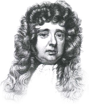
William Petty 1623-1687
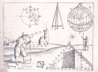
17th Century Surveying
Ireland in the 1650s lay in ruins. Twelve years of calamitous warfare had destroyed the country's infrastructure and resulted in the death of over 20% of the Irish population.

The armies of the English Commonwealth, commanded by Oliver Cromwell, emerged victorious and immediately undertook an ambitious project of social engineering, underpinned by a massive transfer in landownership from Irish Catholics to English Protestants. For this to happen, the land had to be accurately surveyed and mapped, a task overseen by the surgeon-general of the English army, William Petty.
The Down Survey of Ireland
Taken in the years 1656-1658, the Down Survey of Ireland is the first ever detailed land survey on a national scale anywhere in the world. The survey sought to measure all the land to be forfeited by the Catholic Irish in order to facilitate its redistribution to Merchant Adventurers and English soldiers. Copies of these maps have survived in dozens of libraries and archives throughout Ireland and Britain, as well as in the National Library of France. This Project has brought together for the first time in over 300 years all the surviving maps, digitised them and made them available as a public online resource.
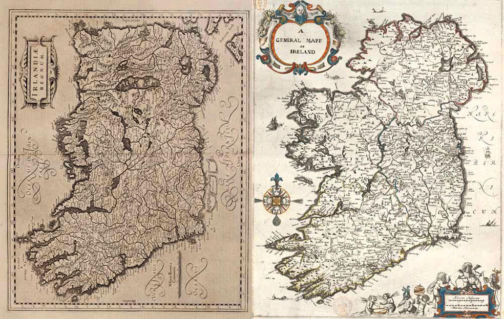
Ireland, the Mercator map of 1570 and the Down Survey map
The Down Survey Website
There are two main components to this website. The Down Survey Maps section comprises digital images of all the surviving Down Survey maps at parish, barony and county level. The written descriptions (terrier) of each barony and parish that accompanied the original maps have also been included. The second section, Historical GIS, brings together the maps and related contemporaneous sources – Books of Survey and Distribution, the 1641 Depositions, the 1659 Census – in a Geographical Information System (GIS). All these sources have been georeferenced with 19th-century Ordnance Survey maps, Google Maps and satellite imagery.

Barony Map
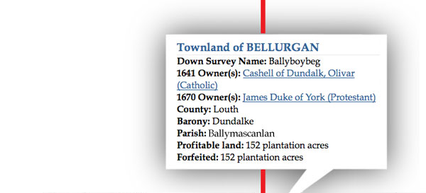
Down Survey Data

Down Survey County Map

Google Map

Satellite Image

Georeference Co-ordinates
A Geographic Information System (GIS) integrates hardware, software, and data for capturing, managing, analyzing, and displaying information that may be geographically referenced. GIS allows us to view visualise data in ways that reveal relationships, patterns, and trends in the form of maps or charts.
No comments:
Post a Comment